
The Sunstone
CLICK: shieldofskuld.substack.com /p/how-did-the-vikings-navigate
Irina Manea 4/24/2026
Discover more from Shield of Skuld
Research and education on Vikings, sagas and the Early Middle Ages.
How did the Vikings navigate?
The risky business of seafaring

It is almost unimaginable for modern humans to conceive of making long voyages across the open sea without some form of navigation instrument. Although some artefacts from the Viking era might have served as navigation tools, there is no certainty that the wandering Norse relied on anything other than their senses to navigate. A tremendous accomplishment and a lesson of humility for us who rely so heavily on all kinds of gadgets to perform diverse tasks.
The tricks and trade of pre-modern navigation
The Norse, well, ancient and medieval people in general, had a deep understanding of nature, but their observations did not result in scientific data that could be used to create very precise instruments. They were familiar with the cardinal directions of east, west, south, and north. However, their navigation was more based on observing the position of the sun on the horizon and its height during the day, rather than Earth’s magnetism, which is the basis for the modern compass.
The sun, moon, and stars provided Northmen with a reliable sense of direction. Yet as you can imagine, in foggy or cloudy weather, these celestial bodies were not visible, and over long distances, even a slight deviation from the planned route could result in completely missing the intended destination. Sometimes a happy result like the discovery of Greenland, sometimes less fortunate when your ship was eaten up by the angry sea and you were sent back with your crew to haunt the living in their homes. To avoid wavy dragons, the Vikings also monitored landmarks when sailing along the coasts. Distinctively shaped rocks or hilltops, for example, could offer valuable clues about their location. You could find descriptions such as this one from Hauksbók manuscript of the Book of Settlements:
Knowledgeable men say that it is seven days’ sailing west from Stad, in Norway, to Horn in eastern Iceland. From Snaefellsness [Iceland], it takes four days at sea to reach Hvarf [Cape Farewell] in Greenland. From Hernar in Norway it is necessary to sail due west to Hvarf in Greenland, passing to the north of Shetland, so that it is just visible, when visibility at sea is good; then the route lies far enough south of the Faeroes that the sea is half-way up the mountains, and far enough south of Iceland that there are both birds and whales. From Reykjaness, in the south of Iceland, there are five days at sea to Cape Slyne in Ireland to the south. There are three days’ sailing from Langaness in the north of Iceland to Svalbard to the north at the head of the sea [the Arctic Ocean, then regarded as a gulf]. From Kolbeinsey to the uninhabited parts of Greenland is one day’s sail northwards.

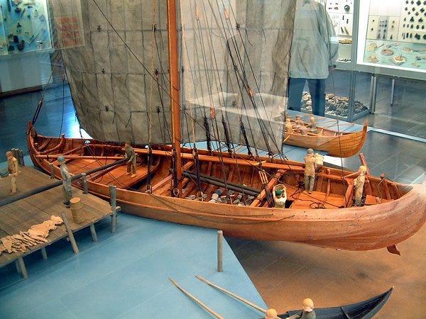
Quite a detailed route for experienced or even beginner sailors. While sailing, the Vikings also used wildlife as navigational aids. Birds were especially helpful, as some species only fly a certain distance from land. For instance, if they had long passed the Faroe Islands and saw a specific terrestrial bird, it could indicate they were near Iceland. Whales, which typically stayed close to fish-filled currents, also provided navigational clues. The Vikings’ knowledge of whale habitats helped them gauge their position relative to locations like Iceland.
Tried and tested sailors relied heavily on their senses too. In dense fog, they could estimate their proximity to land by listening for bird calls or the sound of waves crashing on the shore. Additionally, the sense of touch on their faces helped them detect changes in wind speed and direction, providing insights into wind swells from different directions. Nearby coasts could reflect these swells, allowing a seasoned Viking to gather valuable information from the sea breeze alone. Don’t know about you, but I would trade “computer skills” for that kind of knowledge.
One of the few navigation instruments available to the Vikings was a plumb bob, which they used to measure water depth. This tool also collected small samples of the seabed, which the sailors could taste and touch. An experienced mariner could identify characteristics of the seabed by taste, possibly even detecting fresh water flowing from land into the sea. Additionally, a seasoned sailor could smell their proximity to land. In humid conditions, the human nose can detect the scents of trees, plants, and fires from some distance away.
But sometimes none of this could work, and you would find yourself off course, lost at sea in dangerous circumstances. Or extraordinary ones as well. According to one literary-historical source, Grænlendinga saga (The saga of the Greenlanders), America was discovered by accident in the autumn of 996 AD.
The saga recounts the journey of Bjarni Herjólfsson, believed to be the first European to sight North America while en route to Greenland to visit his father. Having learned the route from Norway to Greenland, Bjarni encountered several days of strong northerly winds and fog, which blew his ship off course. Despite his efforts to steer back on track, Bjarni ended up sailing due west and eventually sighted a piece of land that appeared more fertile than the Greenland he had heard about.
His crew wanted to go ashore, but Bjarni insisted on reaching Greenland before the end of the sailing season. He then headed north, observing that the land became less fertile and rockier. Finally, he saw terrain resembling the descriptions of Greenland and landed near his father’s residence. Bjarni Herjólfsson was not celebrated for discovering new land; instead, he was mocked for his reluctance to explore further. Nonetheless, his travel tales inspired Leif Ericsson to launch his own expedition. Leif “the lucky” bought Bjarni’s ship, assembled a crew of 35, and set sail on his voyage.
The technicalities of sunstones
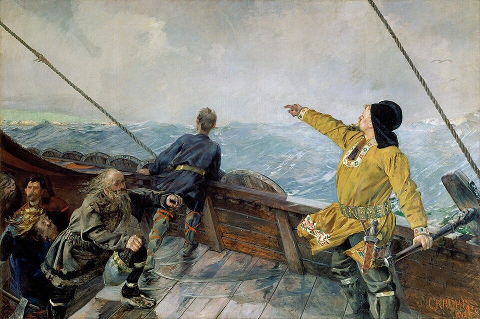
But what about sunstones? If you watched the series, there is a scene where Ragnar uses one, although the context is a bit off since some Northmen at least would have been familiar with the way to the British Isles before the 8th century. While I do comprehend the general public’s fascination with the item, I find the idea of travelling without one more intriguing.
There is indeed speculation that Vikings used sunstones for navigation, but no sunstones have ever been found in Viking excavations. The oldest known sunstone that might have been used for navigation was discovered among the wreckage of the warship Alderney, which sank between England and France in 1592. Some archaeologists have hypothesised that this crystal was used for navigation because it was found about a meter away from another navigational tool.
The Icelandic story Rauðúlfs þáttr (written between the 12th and 13th century) has often been used to prove that the Vikings did use a sunstone as a navigation tool. According to this short tale, in 1030 the Norwegian king Olav Haraldsson II visited a rich farmer by the name Rauðúlfr. Late at night, his son Sigurd was asked about his capabilities. He told the king that he has mastered a skill where he can tell the time of day and night, even if the sky is hidden by clouds.
The weather was thick and snowy as Sigurðr had predicted. Then the king summoned Sigurðr and Dagr (Rauðúlf’s sons) to him. The king made people look out and they could nowhere see a clear sky. Then he asked Sigurðr to tell where the sun was at that time. He gave a clear assertion. Then the king made them fetch the solar stone and held it up and saw where light radiated from the stone and thus directly verified Sigurð’s prediction.
When using a sunstone for navigation, you are not looking for colours but for shadows. By drawing a dot on the top of the crystal and looking through it from below, you will see two dots. If you hold the crystal up to the sky and rotate it until the two dots have exactly the same intensity or darkness, the upward-facing surface of the crystal will indicate the direction of the sun.
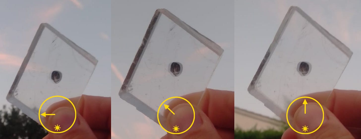
There is no doubt that a sunstone can be used to locate the sun. This method with a dot has been tested, and it was possible to find the location of the sun within one degree, even on cloudy days, or under dark twilight conditions when the sun was just 4 degrees above the horizon.
A study conducted by Gábor Horváth and Dénes Száz at Eötvös Loránd University in Budapest concluded that not only could a sunstone have been a possibility, but it may have been a method to reach Greenland. The research was conducted with the use of computer simulations, based on the theory that the Vikings used Bergen in Norway as a starting point to sail to their settlement in the south of Greenland. The study conducted thousands of computer simulations along the 60°21 55 N latitude.
The Viking voyages were simulated for two specific dates, the spring equinox (21 March) and the summer solstice (21 June). The solar elevation angles were calculated for the latitude on an hourly basis. The speed of the Viking ships was set to 11 km an hour. The Vikings used different types of ships with different maximal velocities, and, therefore, they chose to select an average speed of an average-sized ship with a mast of 21 meters in height. This means that the trip would have taken approximately 3 weeks to complete.
If the sunstone was used every 1 to 3 hours at the spring equinox and summer solstice, then there would be a success rate between 92.2% to 100% to arrive at their destination in Greenland. However, if the sunstone was used every 4 hours, then there would only be a 32.1% to 58.7% chance that the voyages would be successful. If the sunstone was used every 5 hours, then the chances of success would drop to below 4% at the summer solstice, but surprisingly, at the spring equinox, the chances of success were approximately 100%. If the sunstone was used every 6 hours, then the success rate drops to 3.0–6.1% at the spring equinox and 0.9–1.9% at the summer solstice.
Based on these results, they concluded that the use of sunstones for navigation is surprisingly successful at the spring equinox and summer solstice, even in cloudy weather if the navigator uses it at least once every 3 hours. Hence, according to this research, the hypothesis doesn’t sound that far-fetched any longer; however, it is still a hunch. There is no proof that this actually happened, but that it could have happened. Maybe Bjarni did not use a sunstone at all and failed in his measurements.
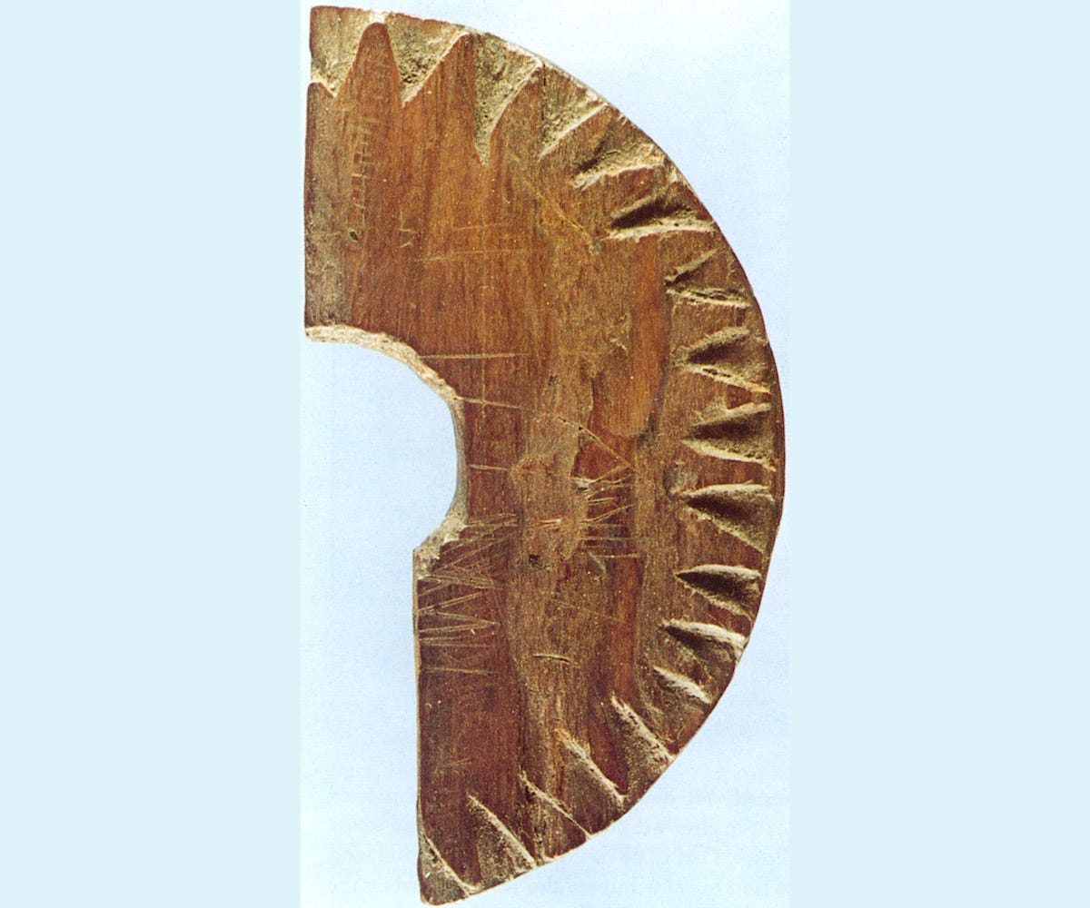
There is yet another, perhaps more exciting candidate for Viking navigational tools: the sundial from Uunartoq. This method involves using a vertical pointer on a horizontal surface, where the shadow of the pointer, known as the gnomon, is tracked throughout the day. The shadow’s path varies at different latitudes and times of the year, necessitating a series of curves for navigation.
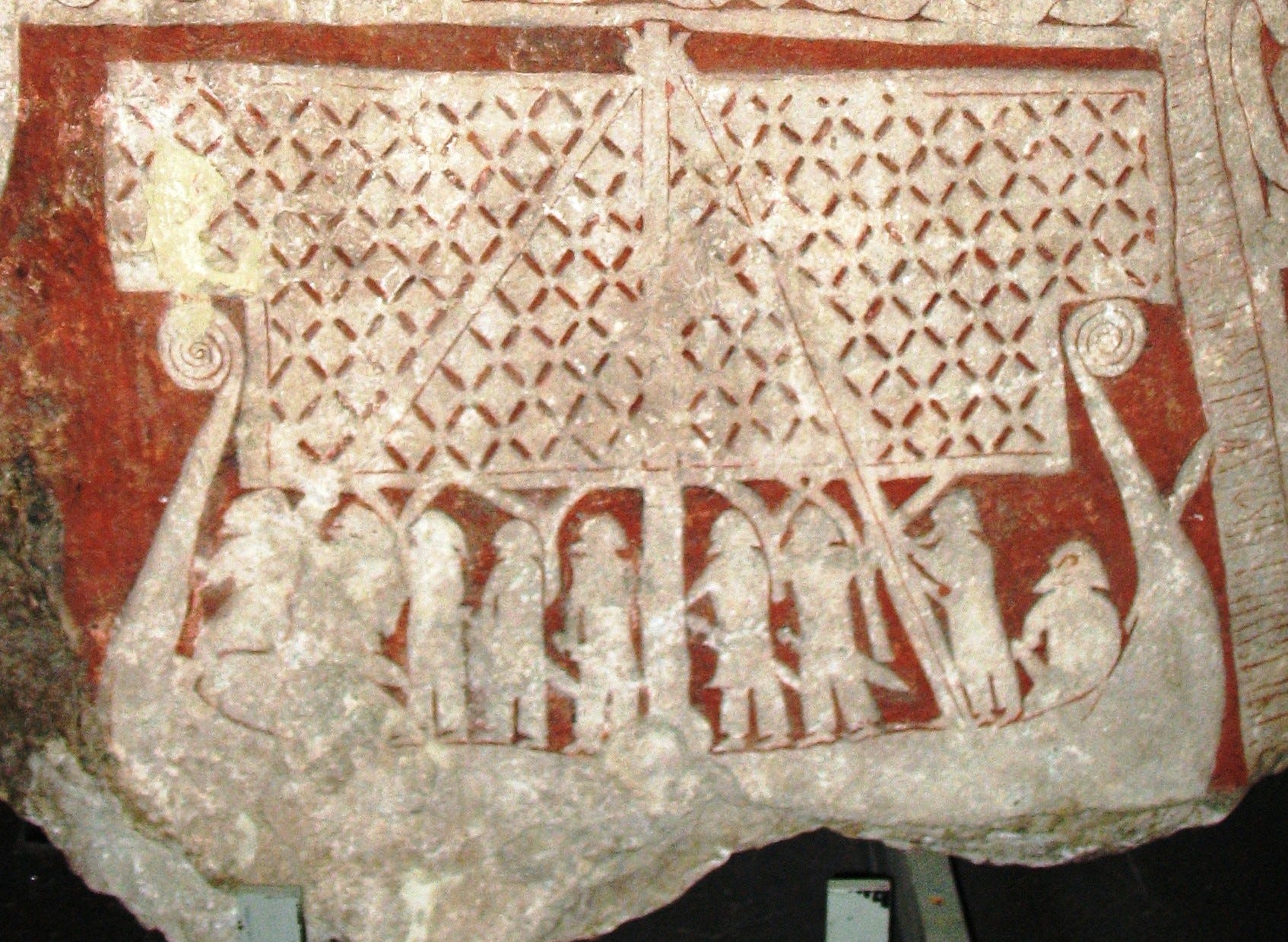
The partial device, resembling a portion of a wheel or disk, had notches carved around its perimeter and intentional scratch marks at distinct intervals across its face, indicating solar alignment. A round peg protruding from the centre of the dial allowed the Vikings to measure the sun’s position in the sky. The key is to measure the sun at the same time each day and note changes in the shadow it casts.
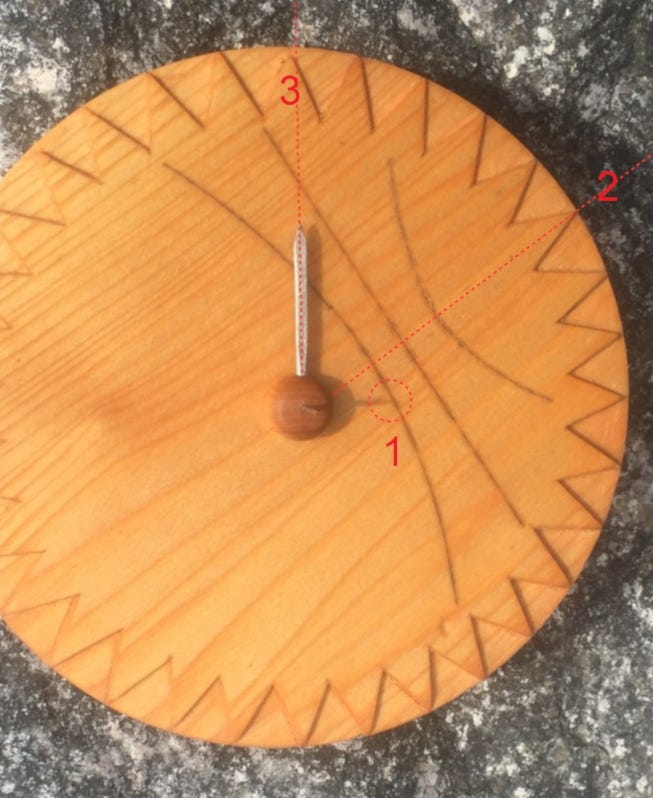
For example, far north of the equator, a noon measurement might cast a shadow to the north. As one sailed closer to the equator, the noon shadow would shorten, eventually passing directly beneath the sun, then growing longer on the south side of the compass as one travelled further south. However, the sun’s height (declination) changes throughout the year, requiring a declination table for extended journeys. Around mid-summer, the variations in declination are minimal, though, making it easier for practical navigation.
The aforementioned study addresses this object as well. One issue with the sun-compass interpretation is that the gnomic lines do not extend all the way to the edge of the dial but terminate prematurely. This truncation would have made it impossible to mark the path of the sun’s shadow past a certain time in the late afternoon. Another issue is that the gnomic lines and some other lines on the dial are slightly misaligned by a few degrees, potentially sending sailors many miles off course.
The researchers suggest that the truncation and imprecision of the gnomic lines are not as problematic as they might seem. The device may not have been used primarily to determine north but to help navigators determine local noon, which, in turn, enabled them to calculate their latitude. To read latitude with such a device, a navigator would measure the sun’s shadow precisely at noon, and the gnomic lines would assist in determining the time of noon. Knowing their latitude would help navigators stay on course during their many east-west voyages between Greenland and Norway.
If this theory is correct, the instrument would have had two gnomons for two separate functions. A short, broad one would have been used with the gnomonic lines to help determine noon. A higher secondary central gnomon would determine latitude. In support of this theory, the instrument has an engraved scaling in the northern part that may have aided this second reading.
In this interpretation, the instrument could be thought of as a sophisticated type of sun shadow board. This is as far as I can deal with the topic; if you’re into optical physics, the article can be found online. For the time being, we have to live with speculation, though, because in the end, all we have is half of a presumed dial and some late references. Nonetheless, even without navigational tools or especially without them, the achievement would have been grand: being able to find your way across the ocean simply by observing nature, from the skies and sea currents to bird species and rocks. Would you have dared to embark on such a perilous journey into the unknown?
Article available in video form as well.


Comments