
Imagine a world where folklore comes alive on a map
Monstrous map of monsters!
Old and new in one innovative map
Imagine a world where folklore comes alive on a map, where the very landscape tells chilling stories of devils, giants, vampires and mermaids! What if I told you that researchers have created such a map, blending centuries-old tales with cutting-edge technology and Renaissance art?
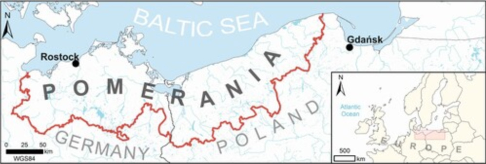
Below is a map of the supernatural beings of Pomerania, a culturally rich region spanning modern-day Poland and Germany.
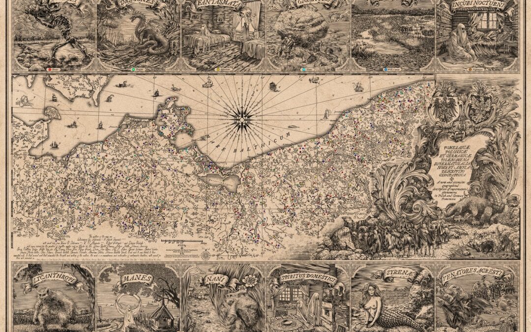
The map connects exhilarating myths and stories to the very land we walk on. A groundbreaking project presents an ambitious effort to visualise centuries of folklore, attempting to revive the cultural imagination of a region shaped by its history and geography. By blending modern geographic information systems (GIS) with artistic techniques inspired by Renaissance cartography, the researchers have created something truly unique. But why Pomerania, and why supernatural beings?
Pomerania, a region that has shifted between Polish and German rule, is a cultural crossroads. Its history of border changes, ethnic diversity, and rich folklore make it the perfect canvas for a project about supernatural stories, deeply tied to the natural landscape. Giants rolling boulders, will-o’-the-wisps flickering in wetlands, mermaids lurking in rivers, restless undead lurking in the dark. These tales reflect our deep-seated fears and how they materialise in monsters, and also how people interpreted their surroundings.
The project’s foundation lies in folklore collected by 19th and early 20th-century ethnographers. These researchers documented myths and legends tied to specific locations in Pomerania. Such as:
‘The devil’s stone near the river, where locals claim he sat to rest.’ (Sagenbuch des Preußischen Staates by Johann Georg Theodor Grässe)
‘A mermaid’s song could be heard near Lake Świdwie on full moon nights.’ (Podania Kaszubskie by Stanisław Czernicki)
‘The wild hunter’s spectral figure was said to race across the skies above the forest of Bukowa Góra.’ (Pommerschen Sagen by Alfred Haas)
‘At the crossroads near the old oak, a ghostly figure waits for travellers at midnight.’ (Märkische Sagen und Märchen by Adalbert Kuhn)
‘The giant’s steps can still be seen on the hill where he roamed.’ (Volkssagen aus Pommern und Rügen by Ulrich Jahn)


The supernatural beings were divided into 12 categories:
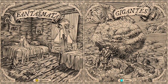
devils - mischievous and often destructive, associated with boulders and ruins
giants - towering figures linked to the shaping of the landscape, like hills and erratic stones
mermaids - enchanting yet dangerous water spirits said to dwell in lakes and rivers
will-o’-the-wisps -mysterious lights in marshes, believed to be souls of the lost
gnomes - small, magical beings guarding treasures or aiding households
wild hunters - spectral riders racing across stormy skies with barking dogs
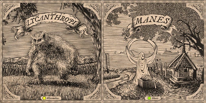
ghosts -spirits tied to tragic events, often haunting crossroads or ruins
dragons - serpentine creatures lurking in wetlands, linked to local fears of the unknown
apparitions -vague, otherworldly forms that defy explanation
nightmares -demonic beings haunting sleepers, causing night terrors
household spirits -protective ancestors believed to reside near hearths
werewolves: cursed humans transforming into wolves under magical influence
As you can notice, many of these entities are linked to what we might deem liminal places, like wetlands and crossroads, or landscape markers that truly stand out. Out of 1,500 recorded beings, 600 were precisely mapped, weaving an amazing visual tapestry of Pomerania’s folklore. This map is also a crafty endeavour. Drawing inspiration from Renaissance cartography, decorative elements like vignettes and cartouches were incorporated, evoking the fornlorn aesthetic of historical maps. The team used linocut techniques to create 12 detailed illustrations of supernatural beings, but also modern tools like Photoshop to ensure precision and seamless integration of these artistic elements.
Why Renaissance inspired? Renaissance cartography saw maps evolve from purely functional tools to objects of aesthetic and intellectual admiration. They became sophisticated works of art, showcasing the cultural refinement and worldly knowledge of their owners, and were even considered an artistic genre in the Italian Renaissance. They were known for their elaborate decorations, including cartouches, richly illustrated legends, marginalia, and vignettes. Anything to appeal to intrigued viewers and engagingly convey information.
They would often include fantastical elements alongside real geographical content, encouraging you to explore and discover how depicted phenomena were tied together. The map of supernatural beings follows this approach by placing creatures within specific landscape contexts. During the Renaissance, science and art were intertwined. Cartographers like Willem Janszoon and Joan Blaeu fused aesthetic pleasure and geographical information in their concoctions.

However, the modern map deviates slightly in its use of colour. Instead of the muted pastels typical of the era, it utilises more intense and unambiguous hues. This choice reflects the authors’ belief that muted colours in historical maps were a result of printing limitations. The map reveals some fascinating patterns. Devils dominate, making up 26% of all beings, while giants, wild hunters, and gnomes together account for 34%. This is all related to how people used to perceive the environment, paranormally charged, frightening and yet enticing. That devils and giants dominate may have to do with the young-glacial landscape of the area. The terrain, ripe with numerous erratic boulders, moraine hills, and deep lakes, seemingly required explanation and storytelling, leading to an invasion of folkloristic ghouls.
Gnomes, often linked to the cult of guardian spirits and the world of the dead, frequently dwell near barrows, erratic boulders, and hills. This pattern means that these beings cannot be divorced of specific topographical elements and ancient burial sites. Wild hunts, a concept prevalent in German-speaking areas and Northern Europe, are linked to sudden atmospheric phenomena like strong winds. Their representation on the map again reflects the region’s cultural beliefs and the attempt to explain natural events through folklore. Which, frankly speaking, still charms the imaginative mind more than the dry science can manage.
This project can preserve cultural heritage through maps, and I’m looking forward to similar maps for other regions, bringing folklore to life in new, enchanting ways. It’s a reminder that the landscapes around us hold stories waiting to be uncovered. Any supernatural beings you fancy? Write in a comment below!


Comments